Contents of this page may be automatically translated, we take no responsibility for the accuracy of the translation. Feel free to contact our customer support centre if you have any questions.

The geoid is one of the most important concepts used to explain what is meant by the "shape of the Earth".
About the geoid
The geoid can be simply described as the surface that coincides with the undisturbed mean sea level over the oceans and with its imaginary continuation under the continents.
More precisely, the geoid is the level (equipotential) surface of the gravity field of the Earth that best coincides with mean sea level. Such a level surface is a closed surface that is everywhere perpendicular to the direction of the gravity vector (the plumb line). An undisturbed liquid surface will adjust to a level surface. The geoid is also the reference surface to which levelled heights refer ("heights above sea level").
Geoid heights and geoid models
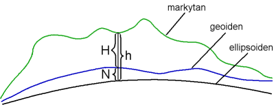
Today, satellite techniques are used on an increasing scale for positioning. The heights obtained with GNSS measurements are expressed relative to a reference ellipsoid. To convert heights above the ellipsoid, h, to heights above sea level, H, the separation between the two surfaces must be known. The separation is called the geoid height, N. The concepts are illustrated in the figure and the relationships by the equation below.

h = H + N
A geoid model is a spatial representation of the geoid height, which can be used to convert ellipsoidal heights h to heights above sea level H. It should be noted that the term geoid model is used here in a rather loose sense. In cases where components other than the geoid height are included, for instance different types of corrections, it is in some circumstances common to prefer terms like height correction model. However, as the differences from the true geoid heights are comparatively small, we will not follow this convention here, but will use the terms geoid height and geoid model.
Interactive computation of geoid height
Compute geoid height, using the national geoid models.

