Contents of this page may be automatically translated, we take no responsibility for the accuracy of the translation. Feel free to contact our customer support centre if you have any questions.

RT 90 (Rikets koordinatsystem 1990) was used for map production by Lantmäteriet before SWEREF 99 was adopted as the official reference system in Sweden.
National map projection
The conformal Transverse Mercator projection is used for mapping. The projection parameters that were used with RT 90 are given below. The official Swedish name of the grid system is RT 90 2.5 gon V 0:‑15, which sometimes also used to be called "Rikets nät".
The coordinates that are obtained using the projection are given in a system where
- x coordinates are measured northward from the Equator, which has an initial x value of 0 metres
- y coordinates are measured from the central meridian, increasing eastwards. To avoid negative values a false easting is used.
The central meridian was originally defined as 2.5 gon west of Stockholm's old observatory but is today defined relative to Greenwich. (1 gon = 0.9 degrees.)
| Parameter | Value |
|---|---|
| Reference ellipsoid | Bessel 1841 |
| Semi-major axis (a) | 6377397.155 |
| Inverse flattening (1/f) | 299.1528128 |
| Type of projection | Transverse Mercator |
| Central meridian | 15°48'29.8' E of Greenwich |
| Latitude of origin | 0° |
| Scale on the central meridian | 1.0 |
| False Northing | 0 m |
| False Easting | 1 500 000 m |
The older coordinate system RT 38 was also used in conjunction with the Transverse Mercator projection as well as the regional systems (RT R). The latter coordinate systems are used with suitably chosen central projection zones.
Projection zones

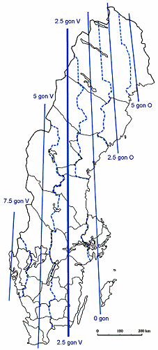
Mapping of Sweden in one projection zone would lead to projection errors of up to 2 m/km, which is not acceptable for large scale mapping and surveying (scale > 1:10 000). Sweden is therefore divided into six projection zones, each with its own central meridian.
The distance between the central meridians is 2°15' (2.5 gon). The remainder of the projection parameters are the same as for 2.5 gon V, except that a local origin is used in some cases, see below. The limits of the zones (dotted lines) are defined so that they follow administrative boundaries.
| Central meridian | Corresponding longitude relative to Greenwich |
|---|---|
| 7,5 gon V | 11°18'29,8"E |
| 5 gon V | 13°33'29,8"E |
| 2,5 gon V | 15°48'29,8"E |
| 0 gon | 18°03'29,8"E |
| 2,5 gon O | 20°18'29,8"E |
| 5 gon O | 22°33'29,8"E |
Local origin for coordinates
In Sweden a special notation is used for the presentation of the different false northings and false eastings which is given as an extension to the notation of the coordinate system.
The system with different false northing and false easting was developed at a time when coordinates were mainly handled in analogue form. Today transformation of geographic data can be complicated due to such local origins, since the information about the false northings and eastings often has been lost.
Some examples of local origins
- "0:-15" is the same as the standard case with x0 = 0 and y0 = 1 500 000 m
- "61:-1" means x0 = -6 100 000 and y0 = 100 000 m
("61:-1" can also be written as "61:14-15")
How large is the difference between latitude and longitude in RT 90 and other reference systems?
The difference between latitude and longitude in RT 90 and globally adapted reference systems (pdf, in Swedish, new window) (SWEREF 99, WGS 84 and others) is about 100–300 meters in Sweden.
In order for a position expressed as latitude and longitude to be unambiguous, one must specify which reference system is used.
The field survey
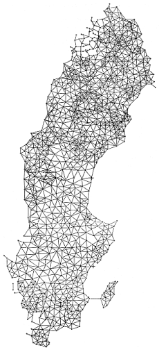
 The third national triangulation programme began in 1967 in the far south of Sweden and when it was completed in 1982 the whole of Sweden had been covered by a first-order network, with an average distance of about 30 km between stations, which was simultaneously densified with a second-order network in which the distance between stations was, on average, 10 km. Unlike classical triangulation, the terms first and second order represents a difference in side lengths and not a classification of accuracy.
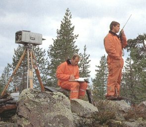
The field programme was based on trilateration methods: initially using MRA 101 Tellurometers which were later replaced by Model 8 laser Geodimeters. Of the 15 800 distances that were measured, 85% were measured with Geodimeters. The majority of the measurements were made from specially designed lightweight towers which could be quickly built up to a maximum height of 30 m. In total, some 3 800 stations were determined with a relative length accuracy of 1–2 ppm (mm/km).
Adjustment of the measurements
In order to make new coordinates available as quickly as possible, Sweden was divided in twelve regions, which were named as RT R01 to RT R12. When field work in a region was completed coordinates for the region were computed and made available. The computation programme began in the southernmost region and continued region by region northwards as the field work was completed.
In the adjustments one station with coordinates in RT 38 or from one of the adjacent regions was held fixed. Angular observations from the old first-order triangulations and selected astronomic observations were included in the adjustments.
The adjustments were done using Bessel's ellipsoid 1841 with geoid heights in RAK 70. Horizontal coordinates were computed on the Transverse Mercator projection with local central meridians.

When all twelve regions had been completed a final total adjustment was carried out. The result is called RT 90.

